Hampton VA

CSuePath

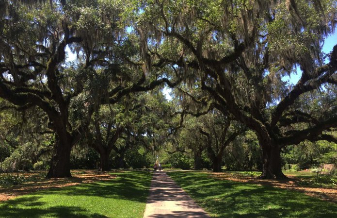
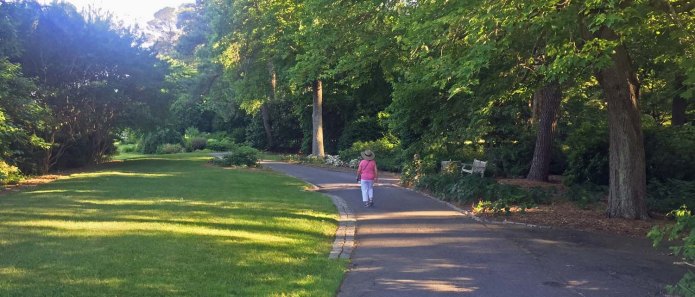
Sue at Norfolk Botanical Gardens. A quiet day before the kids came.

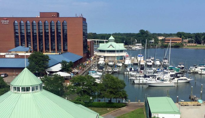
We’re Hampton Public Pier, right downtown in Hampton VA. We’re one block from the NASA Air and Space Museum and a number of restaurants. This area is undergoing a long term revitalization, with a lot of new buildings, wide brick sidewalks, etc. Our rental car is parked right here in the Holiday Inn Crown Plaza garage. We pulled in Saturday after spending one night nearby at Salt Ponds Marina on the lower Chesapeake Bay.

CSGAtHampton

Downtown Hampton Public Pier from the upper deck of the Air & Space museum. We are furthest with our blue dinghy cover on top. Roof for restored carousel is at lower left.

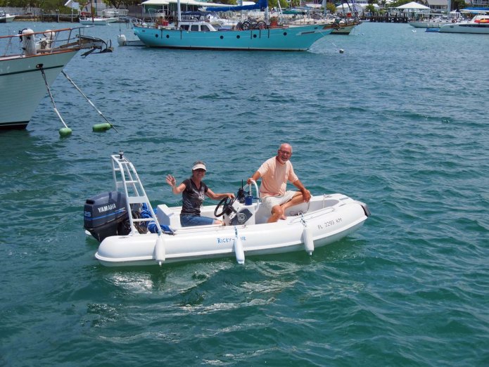
We’ll be here several days while we explore the area. Sue and I saw the Norfolk Botanical Gardens Monday. Not a Brookgreen but very enjoyable, especially to someone who has done as much gardening as Sue. Ethan and Aaron joined us Monday night and we’ve been to the NASA museum with its IMAX theatre, a nearby small history museum and the Virginia Maretime Museum – said to be the largest in the US. We spent today at the Jamestown Settlement. Now we’re back and the kids are fishing off the swim platform.

CPlanets

We’re docked next to a boat that takes people out on 5 hour fishing trips. I’m looking for the right combination of weather and tide to take their early morning trip. Soon the kids will get a dose of culture at the Chrysler Art Museum just a few miles south in Norfolk. One third of its collection is glass which is Sue’s favorite, so we can’t miss that.

CSailShip

An impressive very detailed model of a Venetian galleass at the maritime museum

Will we make it to the battleship Wisconsin, the MacArthur museum or Colonial Williamsburg or a number of other military museums around here or will we take off and explore some of the islands and more rural eastern shore of the Chesapeake before we get up to Annapolis? Too many decisions.

CArmor

Kids in early English armor at Jamestown. I think its on backwards.

Today was the first day business hasn’t dogged me on the phone and email. During May we put our Coeur d’Alene and Texas condos up for sale and contracted to buy a condo in Sarasota FL, so we have been printing, signing and scanning in documents as well as getting a few appliances fixed, arranging packers, etc. That stuff has still been following me the last few days. The Florida one came up right where Sue wanted it at a very good price after a failed sale, so we decided to get it now. We’ll still be living nearly all the time on the boat for the foreseeable future.

Standard

Belhaven

BRopingUp

50% chance a bad blow was coming, so Les tied all 4 boats across to the other side. It didn’t come.

We left Beaufort at 6, taking the south way to avoid the drawbridge where we had the issue with all the small fishing boats last year. The 20’ or less depths inside the NC outer banks gets the water warm this time of year. We saw 83 degrees much of the way. How hot must it get in August?

After a few hours of canal we came on the wide Neuse River, touched the edge of Pamlico Sound and then across the Pamlico and up the Pungo rivers. Look any of these up with Google Maps and you’ll see just how huge they are, and never more than 20’ deep anywhere! The locals call these waters the “Sailboat Capital of the World”

OLYMPUS DIGITAL CAMERA

NC has great trees along the ICW. A lot of forests, some eagles & deer, along our way.

On the Pungo we arrived at Belhaven and docked at our favorite very small (4 boats tops) marina, Belhaven Waterway. Les and Brenda were both out to help us tie up. We were there in plenty of time for dinner at the best very small town restaurant there is, Spoon River Artworks and Market. The local hospital closing was the hot topic on our previous visit. It did finally close, but now people have accepted it. I guess it was losing money for the last 20 years.

We stayed three days. I’ve been puzzling over how to fix the forward facing doors in Sue’s kitchen cupboards for over a month. Crashing into a big wave caused plates and such to lurch forward through the doors and spill out onto the floor. I got a few items from Ace Hardware across the street, Les ground them into shape, I installed them and now Sue just flicks two bolts and all four doors are locked shut.

Our three relaxing days at Belhaven will be followed by two big travel days. About 70 miles each first to Coinjock Marina and then to Salt Ponds Marina, just into the south end of Chesapeake Bay.


Standard

Beaufort Again

OLYMPUS DIGITAL CAMERA

Aground in the SC Rockville. He’s probably already arranged for a tow off when the tide returns. 

If you’re navigating outside along the US east coast, North Carolina is where you encounter three noticeable points to go around. They are capes Fear, Lookout and Hatteras. There are major inlets at Cape Fear and Lookout. Hatteras instead has a lighthouse telling you to keep away. We originally thought that if the waves would stay calm we could have gone all the way from Brunswick GA to Beaufort NC outside, navigating through Frying Pan Shoals around Cape Fear. Instead we entered the ICW at Charleston and continued up that way.

BChurch

Sunday we went to the Methodist church, the oldest in a very old town.

Between Charleston and Beaufort NC the ICW is pretty straight, so our distance traveled was little more than on the outside. The difference is that outside we would travel 24 hours in a day rather than 6 to 8. We can only do that continuously so much, however, because normally neither we nor a weather window can last long enough.

After a long stay in Little River we finally got away, crossed into North Carolina and stopped overnight in Harbour Village Marina in Hampstead. The next day took us to Beaufort NC were Sunday night will be our third. This is our 2nd time here. Beaufort is a small town but big enough to be interesting. It is the third oldest NC town and has long been a seaport. Since we’re on foot, our choice of churches within two blocks of the boat was the First Baptist and the Methodist. We went to the Methodist, which has been there from the beginning of the town.

OLYMPUS DIGITAL CAMERA

Needed a bit of wood to fix something. Thought of going here, but got what we needed in a waste pile along the way.

Greg from Washington NC was in town working on other boats and so came over to do a few things on ours as well. There’s always something to do on a boat. It’s nice to have all the modern conveniences but when you get enough of them together it seems there’s always something that needs fixing. I’m learning more as we go, but when we spend a few days in a place and there’s someone there that fixes boats we just naturally seem to get together.

Standard

Little River SC

AAllee

We started the loop to see stuff like this. An allee at Brookgreen Gardens

We’ve been stuck awhile in Little River SC, very close to the NC border. The boat decided it needed a new genset. We had been fixing the old one a bit more than I liked. Most recently the radiator cap went to pieces as I removed it. Some places, like the Bahamas, it’s hard to get parts, even a radiator cap. The genset was not so large that replacing it was particularly difficult, but it was interesting to see how they get 600 lbs up into the boat and down into the engine room.

ABernard

Discussing world affairs with Bernard Baruch at Brookgreen

The issue is with the generator part, not the diesel that drives it. Nice that diesels last so long. The main engines, which I really don’t want to replace, are fine, and should last considerably longer than we will.

ARestaurant

Museum and garden restaurants are our favorites. Food was actually very good. Our table was on the far left.

Boats are fun. The people next to us in this marina bought a one year old boat. They were just able to leave this morning for parts north after replacing the aircon, which had completely failed. Maybe I repeat myself, but a few phrases I have heard are “don’t buy a boat unless you can be handy to fix things” and “at any one time there are about 5 things wrong with your boat and you know about 2 of them”. I am a bit handy, but don’t rise to the level of replacing 600 lb gensets.

AligatorNest

They have a ride through the back waters just off the ICW. See babies behind mama?

ADianaPond

Diana (to the left) pond.

Places along the ICW are always interesting, and the Myrtle Beach area is no exception. Very touristy with beachwear shops everywhere you look. Not up to Las Vegas but maybe ahead of Pigeon Forge (Dollywood).

One of the places we’ve been to, three times, is Brookgreen Gardens. It is just off of ICW mile 386. North Carolina and the north half of South Carolina have magnificent trees along the ICW, with some of the best in Brookgreen Gardens. We went there on the first of three sunny days and were back again for the other two. We love the botanical part and the sculptures are growing on us. This may be the best botanical garden we’ve been to in our travels, and it is the one we’ve enjoyed most. After this we’ll have to stop at Wacca Wache marina just a few miles north of the gardens. We’ll want to visit Brookgreen each trip up.

ALegoSpider

One of many Lego creations in the zoo here. They each have 20 – 70K bricks.

ASueandTrees

Sue reads about one of the three old plantations that were here before.

We had time to get other business out of the way while here as well, and are ready to be on the move tomorrow. Our immediate goal, with a stop or two along the way, will be Beaufort NC.

Standard

Sailing the Atlantic


OLYMPUS DIGITAL CAMERA

This is the way to sail the Atlantic. Saturday the weather was perfect.

We entered the channel into Brunswick at 2:30 PM Sunday, the day after we started out from West End. It took a bit less than an hour to get to Brunswick Landing marina. Morningstar was much closer to the inlet and a bit more upscale, but charges 2.25/ft. Brunswick is 1.50. That’s not what decided the deal, however. Diesel was 2.63/gal at Morningstar and 1.65 at Brunswick and I’d just used 350 miles worth.

OLYMPUS DIGITAL CAMERA

We got closer to land midway when we passed Cape Canaveral FL

As we got within a few miles of shore I could recheck the weather. Average 3 foot waves, peaking higher, tonight and going through tomorrow. 2 – 3 foot was predicted to the south for today but it seemed less than 1 to us. Maybe we can’t read waves well. Sue’s the one who doesn’t like bumpy roads and such, so I let her decide. She also remembers that the ICW is not maintained well in Georgia, winds all over the place with spots where we have to wait for tide and wonder whether we’ll run aground. She decided to forge ahead.

OLYMPUS DIGITAL CAMERA

Long tow Alice Moran off Canaveral bound for Tampa. 6 miles away to the left followed by its barge under the lowering sun. 

We fueled up and headed right back out to sea. By 6 PM we reached the end of the long Brunswick inlet and turned northeast toward Charleston. At our average 9.7 mph speed the autopilot said we’d reach Charleston inlet around 8:30 AM in the morning. We would be close to land and so could recheck the weather and decide whether to go further or not. Savannah was nearer but it would be night when we reached that, and it’s 17 miles up the inlet and on into the river to reach the downtown marina. I’ll only do the wide open spaces in the dark unless at great need. The same with Cape Fear. We’d reach that by 8 PM, just when it gets dark. So if not Charleston we can go only a little more up to the Georgetown Inlet or all the way to Beaufort NC (not SC). Beaufort would be the next morning after two nights at sea. We would have only considered that if it was really smooth, like it was coming up from West End, and it wasn’t.

So the only reasonable options were either to go in at Charleston or continue on another 5 hours to Georgetown.

Our previous trip was a lot gentler than the predictions. This was worse. It was like our Albemarle Sound adventure with Paul and Sharon. Our ships bell only rang twice, but we were out 15 hours instead of one. In the dark.

OLYMPUS DIGITAL CAMERA

We were ready to put in at Charleston as the sun rose on Sunday.

The boat performed great. We really tested the stabilizers and were really glad we had them. No side to side rock at all. We still had the fore and aft pitching of course. Sue performed fine also, but did decide we would not do something like that by choice again. Our straight line course took us into a just bit of Gulf Stream to help with our speed. We arrived in the Charleston inlet channel at 8:26 Sunday morning and took nearly an hour to get in against an outgoing tidal current.

We rested and then got interviewed by a customs agent who stopped by the boat. We should have checked in in Brunswick, but could not raise anyone on the phone and had to get back out to sea to avoid navigating in the Brunswick harbor at dark.

OLYMPUS DIGITAL CAMERA

Ft Sumpter on our port side from the main channel in Charleston Harbor.

So in two very full days we did what took us 14 days of ICW travel on the loop last year, and we were hurrying last year to get up to North Carolina for our major boat repairs. It’s a great way to travel when the weather is right.

Standard

In the Weather Window

OLYMPUS DIGITAL CAMERA

On longer trips we leave at first light, so we often see sunrise on the way.

I write this as we sail the open Atlantic bound for the north coast of Florida or Georgia.

I now know more about radiator caps. I called a store (AID) in Freeport and ordered what I thought would fit. Freeport is nearly an hour away, but for $25 they delivered it to the marina after we arrived. It didn’t fit. This is where I learned about different cap depths. They offered to take me and the old cap back to Freeport, where they took me to their place as well as a to a competitor. We found caps at each that looked promising, and one of them fit. The other can be a spare for the main engines. They drove me back after store hours and didn’t want anything more for it. They refunded my money for the caps that didn’t fit.

We could still leave! People in the Bahamas do get delayed a few days waiting for a part to get expressed over from the US. I didn’t get back until 7 and we were getting up at 5 AM to leave at 6 to sail the Atlantic, so we tidied up and went to bed.

OLYMPUS DIGITAL CAMERA

Mongoose Hunter came up from behind and passed within 1/2 mile in front of us.

Ideally a weather garage door is better than just a window. Good winds and waves before and after you sail, as well as during, are the best. Predictions are usually good, but they can move a day forward or back sometimes. Looks like that is what we are having today. Yesterday we were exposed to the open Atlantic for just the last mile getting into the West End marina and it was flat. It’s flat again today.

Earlier we passed a couple of freighters, two sport fisherman and the Carnival Elation on its way to Freeport. All these were several miles away except for the freighter Mongoose Hunter. It was 19 mph coming from our right rear at what appeared to be a collision course, but AIS said we’d miss each other by half a mile, and we did when it later passed in front of us. This was all nearer to the Bahamas. Nothing since then.

OLYMPUS DIGITAL CAMERA

7 miles off, Carnival Elation, bound for Freeport, sails under clouds and hits a patch of sunlight. 

As I write this at 1:30 PM we have been going about 7 hours. The boat is set to go 9.5 mph to save fuel. Our speed is now over 13 mph. My original goal was Jacksonville FL, but the autopilot estimates we’ll be there at 6 AM tomorrow! That estimate will get later as we come out of the Gulf Stream, but I think we’ll still be there before 10 AM. We can extend our trip 50 miles and come it at Brunswick GA. At this speed we are using less fuel. So far it appears fuel will easily hold up way beyond even Brunswick. Should we go for Savannah? We’ll decide early tomorrow morning as we get closer.

OLYMPUS DIGITAL CAMERA

Heading north on a flat Gulf Stream with a south wind behind. Doesn’t get better. Hit 14 mph a few times. Speed set at 9.5.

We 40 miles offshore right now, slowly getting closer. That is a bit far from help if something should break, but I’m hoping were good for another 12 hours of running. Almost bathwater flat. Long period rollers maybe a foot high.


Standard

Foxtown, Abacos north island

OLYMPUS DIGITAL CAMERA

On the way to Foxtown. North end of Whale Cay as we pass it outside going north 

Yesterday we came from Marsh Harbor, just across the Abaco Sea from Hope Town, up to Foxtown at the north end of Abacos. It was a calm day, so no drama as we came through the Whale Cay passage again. There were long period low rollers that crashed on Whale Cay shore, but hardly affected us out in the deeper water.

OLYMPUS DIGITAL CAMERA

View outward from our Foxtown anchorage

OLYMPUS DIGITAL CAMERA

Fox town from our anchorage

We made it to the Foxtown anchorage last night. We can easily make it to West End today. Foxtown is very small, but its two gas stations are by the water and there is a small grocery store. Our boat could never go to the town docks and getting there is challenge for even a dinghy. Since we dropped anchor after 5:30 and wanted to leave at first light we just stayed aboard and went to bed early.

OLYMPUS DIGITAL CAMERA

Sunrise as we left Foxtown anchorage

We got up and left by first light at 6:15. When I did the engine checks the genset radiator cap broke into three pieces in my hand. I guess that happens only on an older boat. Thankfully our battery bank was fully charged when we left Marsh Harbor yesterday and should be fine until we reach West End around 3 today. Such a simple thing. I have spares for things you’ve never heard of, but no spare radiator caps! I hope I can get one so we’ll still be ready to go early tomorrow morning.

We are sailing the length of Grand Bahama island above its north shore. We just passed below Great Sale Cay and are bound for the shallow passage just before West End.

OLYMPUS DIGITAL CAMERA

Taken after we passed south of Great Sale Cay. Light areas sand, dark plants & rock. All about 9′ deep.

I’ll recheck tonight, but it looks like Friday and Saturday will good weather to do an outside run and eat up some distance toward the Chesapeake like we’ve been planning.

Standard

Our Big Adventure

OLYMPUS DIGITAL CAMERA

Looking back while leaving Hope Town harbor.

Today was eventful. Much of it was great, and we learned some lessons from the rest. We left the beautiful Hope Town harbor at for an anchorage at Sandy Cay that Active Captain names “Snorkeling”. We dropped anchor around noon with one other boat, a sailing cat, a few thousand feet away.

Of course no one can anchor near a living reef, but since divers want to do just that the government has provided mooring buoys fixed to the sandy areas just off the reef. You must be less than 24’ long to use them, so I dropped the dinghy and went out around to the other side of the reef and tied up.

One of the better places I’ve been to. A great variety of fish, some very colorful, in 4’ to 20’ of very clear water. The reef was different than I have seen, with lots of bright yellow colors. An underwater camera would have been nice to help me describe this, but I’ve never gotten very good underwater photos when I’ve tried before. The descriptions about it do say it is the best in at least the northern Bahamas, maybe the best in all.

OLYMPUS DIGITAL CAMERA

Light house lit by kerosene. Floating on mercury, falling weights rotate it. Tried turning it when up there. Effortless.

The area I tied the dinghy up was pretty rolly with swells coming in from a nearby wide inlet to the Atlantic. Those swells reached the big boat as well, so it was rocking around (our stabilizers don’t do much unless the boat is moving) while I was raising dinghy back to the sundeck roof. Trying to ease nearly 1000 lbs. of dinghy back onto its chocks while it is waving around was way harder than I anticipated. I’m lucky I got it done without injury to the dinghy or me. Dropping it was not as difficult. Next time when in rolly seas we’ll just tow the dinghy back to a calmer place before trying to raise it back up.

Boats are wonderful things but can be pretty frustrating. When we got to our Sandy Cay anchorage and stopped the engines, I heard the water pump running. We weren’t using water so I switched off the pump breakers. When I checked the water tank it was dead empty. We left Hope Town with enough water to last us 2 or 3 weeks! Apparently we sprung a leak, and the water pressure pump happily pumped all our water out to – where? Another fine feature of all of these pumps is that when the water supply runs dry they free run until they burn themselves up. Fortunately I heard them running and shut them down before that happened.

I checked all the sinks, washer, dishwasher, shower, etc. found nothing wet and all faucets turned off. I looked into the bilge (the automatic pump is currently broken, got to fix that too) and found no water there. I had to either go into the bilge or through a drain overboard and it seemed to do neither.

We had planned to return north after seeing the reef anyway, so we set course for Marsh Harbor, the big town (6000!) of Abacos. We could most likely find help there, and did finally learn that a fitting for the washer hot water supply had come loose. It dumped into the rear bilge, which is completely sealed off from the central bilge under the engine room, and was efficiently pumped overboard by the automatic bilge pump there. That one still worked.

Anyway, we’re in Marsh Harbor, where we originally did not plan to come. We can leave by tomorrow, and so have not lost much time in our quest to get back to the US. We’ll do a minor resupply and check out Maxwell’s supermarket tomorrow morning. We can sail out before noon.

Standard

Hub of the Abacos

GTreeShadedStreet

A street in Hope Town

Marsh Harbor is by far the largest town in Abacos with 6000 people. It is more of a working town, however. It is a great resupply place, with the Maxwell’s supermarket, hardware stores and such. Maxwell’s is as large as many us Supermarkets. Its prices are only 1.5 times the US vs. almost 3 times in the smaller markets that all the towns have. Next time we come to Abacos we’ll stock up in the US, but don’t have to worry about resupplying fresh stuff or things we forgot.

GHopeTownChurch

We dinghied into town in time for Sunday service here.

For boaters the true hub is Hope Town on Elbow Cay, just across (the short way) the Abaco sea. It’s harbor is nose to nose boats. The mooring balls are set close together for 40’ or shorter boats, but people do shoehorn larger. When we swung around we could be just a few feet from a neighboring mooring ball. We depend on whoever is on that ball to swing around the same way we do. Most balls are usually occupied. Coming in the morning is the best way to get one. We got ours because our friends “reserved” on for us in the morning for our noon arrival.

GHopeTownStreet

Another Hope Town street

It’s a social place with dinghies going back and forth between boats. We met Lou and his wife Wendy and John, traveling with them. The had just come up in a sailboat from east of Puerto Rico via Spanish Wells. John was with them because you need at least one extra person to take some night shifts, etc. on long sea passages. I guess that makes them hard core sailors. They came over on the ferry on Sunday from Marsh Harbor, and had no transportation. It was a long walk from our restaurant overlooking the Atlantic to the lighthouse they wanted to see on the other side of the harbor, so we took them straight across in the dinghy. After that we all decided to explore White Sound, the other harbor on Elbow Cay to the south. Nothing much to report there. A small marina with mostly powerboats, unusual here where most cruisers have sailboats. A bit shallow and winding to get in which may drive the sailboats elsewhere.

GBeachAtRestaurant

Lunch here overlooking the Atlantic then off to a small adventure with new friends.

It would have been great to stay longer, but we came to the Bahamas more than a month later than we originally planned, so decided next year we would slow down the pace and stay longer in more places here. Hope Town will deserve a week at minimum. This time we’ll leave tomorrow after two nights. A live reef 20 miles south has been restoring itself over the last few years. It’s said to be a great place to snorkel. I’ve got to see that.

Standard

Whale Key Passage

OLYMPUS DIGITAL CAMERA

They got in first and radioed a report, then we passed our friends on Otter in the Whale Cay passage

One thing people heading south in the Abaco Sea do at Green Turtle Cay is wait for the Whale. We’ve been wanting to get south and talked with our friends about striking out Friday morning. Otter’s captain said “I’m sure you’ll make it, it’s been worse, but you’ll get pretty beat up.” He planned to go also and was going to wait one more day.

Travel through the Abaco Sea is protected and unhindered except at Whale Cay. A shifting sand bar stretches from the main Abaco island all the way to the Whale Cay barrier island, preventing boats larger than our dinghy from crossing that way. Instead we have to go out on the open Atlantic at the north end of Whale Cay and back into the Abaco Sea at the south end. The north passage is only 15 feet deep. Significant wind from the NE or swells from storms thousands of miles away can produce breaking waves across this entire passage. They call it the “rage” condition, and it can be life threatening.

OLYMPUS DIGITAL CAMERA

Tough to get a mooring ball in Hope Town on Saturday. Friends Jim & Belinda from Rickshaw marked one for us.

Fortunately, when traveling south, you can turn back if you see waves breaking across the inlet. It is also common to call out on channel 16 asking who has recently done the Whale. This is the only “weather window” to wait for in the Abacos, and usually not more than a day or so.

When we started out I heard someone else call out on 16 before I had a chance. Someone who just completed the passage answered and said conditions were fine. When we got there the waves seemed around 2 feet, no problem at all. We were outside is only 30 minutes, and went back into the Abaco Sea via and old channel made for a cruise ship, “The Disney Big Red Boat”, that used to call on Guana Cay, the next major cay after Whale Cay, before 1993.

FHopeTownInnMarina

Hope Town Inn & Marina. Kerosene lit lighthouse and our dinghy below it a bit right.

We went another 20 miles to Hope Town harbor and arrived at noon. Hope Town is one of the busiest places in the Abacos. Fortunately our friends Jim and Brenda Wolfe had “saved” a mooring ball for us and helped us to tie up to it.

We had only an hour to talk to them before they had to leave for and anchorage 20 miles further south. There they’ll be ready to take off to Spanish Wells on Harbour Island, 60 miles south of the Abacos. The weather window, which opens more seldom than for the Whale, is tomorrow.

FHopeTownHarbor

We float just a bit left of the center of this picture. Atlantic Ocean is beyond. Harbor entry to left, marina to right.

We won’t go any further than 20 miles south of here, then we’ll return northward on the Abaco Sea and, weather permitting, jump straight over to northern Florida.

Standard